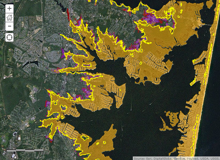
An image on the US eastern seaboard indicating where flooding is expected to occur.
Google, Microsoft and Intel have signed themselves up to provide mapping data and information to the US government as part of US President Barack Obama’s Climate Data Initiative.
The government has released a new climate.data.gov webpage dedicated to monitoring the continued effects of climate change using the map technology these companies possess with their various satellites that will be able to initially chart an area’s coastal flooding and sea level rise, with their visible impacts.
In the White House’s official release on the project, it explained Google’s mapping and cloud technology, in particular, as having a particularly significant contribution to local communities looking to plan for any future flooding issues.
“Google will donate one petabyte – that’s 1,000 terabytes – of cloud storage for climate data, as well as 50m hours of high-performance computing with the Google Earth Engine platform. The company is challenging the global innovation community to build a high-resolution global terrain model to help communities build resilience to anticipated climate impacts in decades to come.”
Intel is also planning to host three climate-change hackathons in the US this year to challenge engineering and computer science students to create helpful new apps and tools from existing federal data.
Meanwhile, Microsoft has launched a competition to find 40 research projects on the project, each which will receive Azure access to the tune of 20 terabytes of storage and 180,000 hours of runtime.
The number of maps will be continually expanded in the coming months and years as they receive more contributions from other areas of the scientific community.
Intel and Microsoft are Silicon Republic Featured Employers, comprised of top tech companies that are hiring now