Image: © bodnarphoto/Stock.adobe.com
Google Maps will soon start rolling out a visual update that will make the natural world more clearly represented and streets more navigable.
More visible mountains and terrain will be included in a new update set to roll out for Google Maps in the 220 countries and territories where the app is supported. The update will add colour coding to maps of the world to allow users to more easily distinguish arid beaches and deserts from blue lakes, rivers, oceans and ravines.
In a blog post, Google said this update is based on a colour-mapping technique sourced from scanned satellite imagery of arid, icy, forested and mountainous regions. These features are then analysed and assigned a range of colours on the HSV colour model.
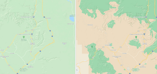
Comparison between the older version of Google Maps (left) and the newer one (right) showing clearer natural details. Image: Google
The end result, Google said, is a map that is easier to explore visually, but also better for exploring on the ground by telling the user what terrain may lie ahead or what they can expect when planning a trip.
For example, a densely covered forest can be classified as dark green, while an area of patchy shrubs could appear as a lighter shade of green.
Accessibility boost
Cities are also set to undergo a major visual update designed to help them be more navigable, with a clearer representation of what streets and places look like.
“Soon, you’ll be able to see highly detailed street information that shows the accurate shape and width of a road to scale,” said Google Maps product manager Sujoy Banerjee.
“You can also see exactly where sidewalks, crosswalks and pedestrian islands are located – crucial information if you have accessibility needs, like wheelchair or stroller requirements.”

Comparison of the older street view on Google maps (left) and the newer version (right) with clearer pedestrian information. Image: Google
Banerjee also said this information is particularly important as more people are walking or taking other forms of personal transport as a result of the Covid-19 pandemic. Unlike the nature update, the city visual update will start rolling out in London, New York and San Francisco in the coming months, followed by other cities over time.
Google Maps was only recently updated to include driving alerts, notifying travellers about Covid-19 checkpoints and restrictions in their chosen routes.