If you happen to spot a black car with the Google logo cruising past you this week, give a wave. This is the famous Google car, used to capture panoramic images for Google Maps’ Street View and, following its mapping of cities around the US and Europe, it has finally arrived on Irish shores.
Street View is Google’s online, interactive, panoramic street-level photographic mapping system that is integrated into Google Maps, aiming to give us an up-close look at public streets and their environs.
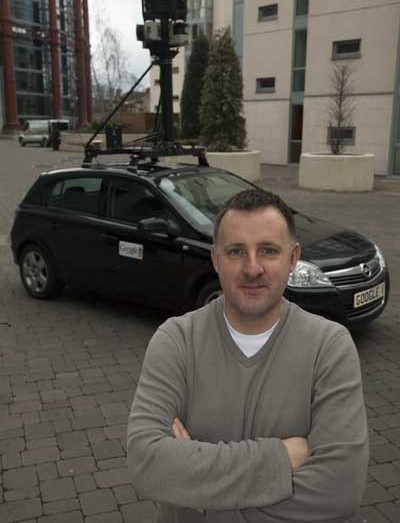
The Google car — equipped with GPS and camera equipment — has already been out on the beat since Monday, snapping images of Irish streets in a training exercise ahead of its task to map the five major Irish cities: Dublin, Cork, Limerick, Galway and Waterford.
While Google is getting in gear with a test drive this week, to be followed by the initial phase of mapping, its geospatial technologist, Ed Parsons, says the process, from gathering data to the final Street View, will take any time from three to four months to up to a year.
The city centres will be covered, and so too will suburban and outlying areas, depending on population density and business activity.
Although Street View is a series of images captured from the Google car, pedestrian zones such as Grafton Street will also be covered, he says. However, Parsons is not able to divulge how this will happen.
Full Street View is also viewable on the mobile phone, currently limited to Google’s G1 Android device, which has not been given an official timeline for release here in Ireland.
As for privacy issues surrounding Street View, Iarla Flynn, European policy manager for Google, states that advanced technology blurs out both faces and registration plates to protect identities and preserve privacy. Individuals can also report further details captured by Street View that they feel is inappropriate.
Street View is a free online service from Google, so while the company does not directly make money from rolling this out to Irish cities it does benefit indirectly, says Parsons.
Many businesses choose to embed Google Maps functionality in their websites to help customers find them, thus spreading Google’s services to a further audience, he explains.
“Street View is additional to the existing search business — it adds to Google’s search industry,” he says.
Aside from business uses, Street View is also being used for recreational purposes, explains Parsons. In cities mapped with Street View, potential tourists can play a more interactive role, finding out how to get to the train station or seeing where their hotel is located.Google tourists, it seems, are streets ahead.
By Marie Boran
Pictured:Ed Parsons, geospatial technologist, Google Maps