Given the seeming national obsession with property it comes as little surprise that when local authorities make planning information available online, the public beats a path to their door.
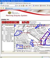
That was certainly true in Cork County Council’s case. Citizens can access its Planning Enquiry and Analysis System through the web at www.corkcoco.ie.
There have been more than a million hits to the site and of that figure, 45pc relate to planning. “It’s far and away the most popular section of the site,” confirms Julianne Coughlan, GIS (geographical information system) officer with Cork County Council’s ICT department. “Initially we started capturing boundaries for planning information in January 2003. Since then we have had a number of internal releases of the system. The external version has been open to the public for the past two years.”
As often happens with public sector information systems, what was originally developed for internal use has been made available externally. “Our primary objective was to support the planning internally and make it as efficient as we could,” Coughlan explains. “Since there are so many departments involved indirectly — for example, an application might start in the planning department but would need an engineer or environmental inspector to take a look at it — it passes a lot of people’s desks so getting them easy access to the information was our initial aim. Obviously then you want the public to track their application as quickly as possible.”
The system has helped to overcome many logistical and organisational hurdles. Cork has one of the largest local authorities in Ireland, with more than 100 offices throughout the county. In addition, there is a lot of activity in this area. There were more than 13,000 planning applications in 2006 and on current estimates this year’s figure is likely to be a similar level.
The system has helped eliminate backlogs in the planning application registration process. This now happens quickly and simultaneously. All submitted documents are scanned and these digital files are made available to the council’s staff through the Planning Enquiry and Analysis System. Detailed design drawings, correspondence, area planner reports and engineer’s reports are all accessible to the appropriate personnel through the system.
Planners can also access the key information about an application as soon as it has been registered. The system displays site location information along with other relevant Cork County Council GIS datasets so the planner can make a comprehensive assessment of the application. Since making the information available online, there has been a notable reduction in members of the public visiting in person.
The Planning Enquiry and Analysis System was developed by Cork County Council with the IT provider 1Spatial Ireland. The Web GIS element of the system is built on Autodesk Mapguide software, which produces small file sizes so that the applications don’t take long to download. Although all of the county council’s offices are being upgraded to broadband, this still means citizens on low-speed internet connections can easily look at the system.
“We had to be very conscious of that when choosing the technology,” says Coughlan. “It was the most user-friendly and that was an advantage as well.”
The system also shows the benefits of collaboration between local authorities, Coughlan adds. The data capture part of the system was initially developed by Kildare County Council. Cork County Council worked on the planning enquiry element that lets people access the information.
Rather than embarking on their own development from start to finish, both councils then provided the respective parts to each other in order to build a complete system. Since then, the total solution has been rolled out to several other local authorities, including Limerick City and County, Kerry County Council, Cork City and Galway City.
“Ideally where we want to go is to develop a series of online services. We have internal GIS datasets. We want to make those available through an online interface,” says Coughlan. This could involve notifying residents with an alert whenever a planning application is made in their area. “It’s certainly possible with the technology that’s there.”
The council has also scored a notable coup — not only has it made the planning enquiry system open to the public, but this year it became the first body in either the private or public sector to be awarded an excellence standard in accessibility for its website on first application.
“The accessible version is fairly unique because GIS traditionally is a visual technology. It’s not something that people consider being made in an accessible version,” Coughlan remarks. “The award recognised our commitment to the public and this version also facilitates our own staff who may have similar issues.”
The long-term aim is to provide even more geographical-based services in accessible format. A likely candidate for such a move is a tool for performing spatial analysis. Users can query multiple layers of information against each other and even mark up features on the map themselves.
“That’s now available to the public, but not in the accessible version because of the more complex work with the map,” Coughlan explains.
The council has mandated that any technology providers looking to provide web development services must implement a minimum level of accessibility. “That’s something we’re looking to implement across the board. Future versions of the systems already in place will have to meet those requirements,” Coughlan concludes.
By Gordon Smith