Moscow lit up by the Strava heatmap. Image: Strava
Bragging about your latest run might have security implications.
A global heatmap published by running app Strava lights up a world of fitness. But one unforeseen circumstance has been how neatly soldiers’ jogging routes also reveal the layout and design of top secret military bases.
Yes, we all have those friends who put us to shame when they publish their latest running routes and accomplishments on social media, and Strava is often the app of choice for its accuracy and visual style.
The fitness app firm published a beautiful depiction of how fit people around the world are adding to the tapestry of data lighting up our world.
Its heatmap captured 1bn activities, and 3trn latitude and longtitude points. 13trn pixels were rasterised and some 10 terabytes of raw data captured on 27bn kilometres of physical activity, from running to cycling and swimming.
In all, some 200,000 years’ worth of total activity was recorded and 5pc of all land on Earth was covered by the heatmap tiles.
A cartographer’s dream, but a tactician’s nightmare?
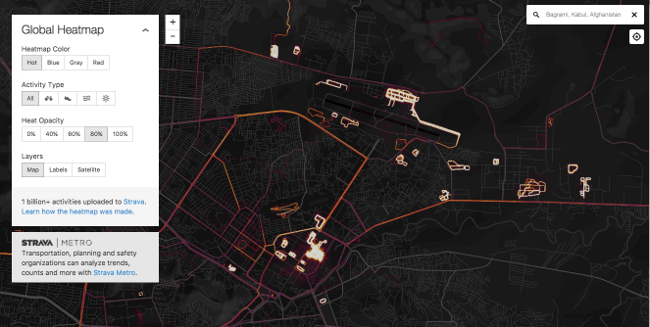
The military base at Basra in Afghanistan stands out like a sore thumb on the heatmap. Image: Strava
These tiles present pretty pictures of the worlds’ cities and jogging routes.
That’s all well and good but the security world is piqued by the fact that these heatmap tiles also show the structure of military bases in countries like Syria and Afghanistan.
You see, soldiers’ favourite jogging routes are often inside the perimeter of these bases. Captured on the heatmaps, this provides data as neat as if rendered from an architect’s pen – only in neon.
As an unforeseen circumstance, soldiers’ jogging routes captured by fitness tracker app Strava could turn out to be a goldmine of intelligence for terrorists.
It is understood that the US military is examining the data.
The maps had been public since November 2017 but, in recent days, an Australian student called Nathan Ruser pointed out the obvious.
Strava released their global heatmap. 13 trillion GPS points from their users (turning off data sharing is an option). https://t.co/hA6jcxfBQI … It looks very pretty, but not amazing for Op-Sec. US Bases are clearly identifiable and mappable pic.twitter.com/rBgGnOzasq
— Nathan Ruser (@Nrg8000) January 27, 2018
While Strava said it excluded activities marked as private from the map, it is down to users to decide if their data is public or private.
In their zeal to keep fit – but also, perhaps, show their efforts to friends, soldiers and other military personnel – these users have drawn a precise digital picture of military bases for all the world to see. As a result, outlines of perimeters and patrol routes have been online since November. Because the app is popular in western world countries, military bases overseas are even more pronounced as isolated hotspots on the Strava map.
Strava is an app beloved by runners and the data captured is marvellous to behold in visual form. What will happen next, now that that military brass have been alerted to something they have overlooked, is anybody’s guess. But you can be certain it may inform future policy on these bases.