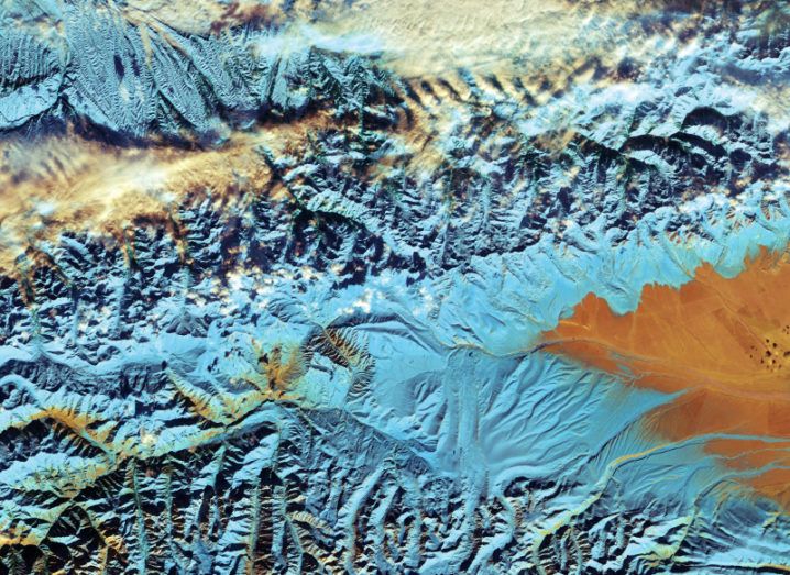
China’s Tian Shan mountains. Image: Copernicus Sentinel/ESA
The ESA’s Sentinel-2 satellite has produced a brilliant false-colour image of China’s Tian Shan mountain range, though it’s worrying from an environmental perspective.
The latest image of Earth released by ESA shows a cluster of mountains in the north-west region of China, a section of the 2,800km Tian Shan range.
Towards the border with Kazakhstan and Kyrgyzstan, it’s one of the longest mountain ranges in Central Asia and, through satellite imagery, ESA is trying to track environmental changes, of which there are quite a few.
According to ESA, the glaciers of Tian Shan have lost about a quarter of their ice mass since the 1960s, with estimates of it halving from its current state by 2050. “Glaciers are a key indicator of climate change, and their melting poses threats to communities living downstream,” said ESA.
The reason the image looks so interesting is because of the false colour, which is a necessity, rather than a style choice.
Clouds and snow are both white, so any image in real colour would make it difficult to differentiate between the two. But Sentinel-2’s technology allows it to view the area “in different parts of the spectrum”, producing an image that separates the two.

China’s Tian Shan mountains. Image: Copernicus Sentinel/ESA
So here the clouds are white, the snow blue, and grasslands are orange.
The orange area on the right side of the image is part of the Bayanbulak Basin, a large grassland area of about 24,000 sq km.
The basin, largely out of shot, is a key wetland in China, representing the highest-altitude breeding ground for swans in the world.