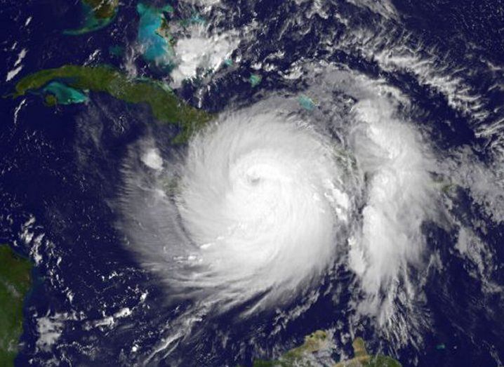
Image of Hurricane Matthew taken by NOAA's GOES East satellite at 7.45 am EDT on 4 October, within the hour of landfall in western Haiti. Image: NASA/NOAA GOES Project
The Caribbean nation of Haiti is being bombarded by Hurricane Matthew, a 230kph wind considered one of the worst to hit the region in nearly a decade.
At the time of writing, Hurricane Matthew is a Category Four storm – of which there are only five categories – making this one of the most damaging storms of the past decade, bringing back painful reminders of Hurricane Katrina in 2005.
Having already hit the southern tip of Haiti, the hurricane is expected to progress northward past the eastern tip of Cuba, before making its way to the ocean off the coast of Florida with a current speed of 17kph.

As the one of the poorest countries in the world, and the first to experience the brute force of Hurricane Matthew, Haiti has already reported that much of the affected area has been severely damaged.
Poorly constructed dwellings have been destroyed, many of which were built following the devastating earthquake that occurred in the region in 2010, which was estimated to have killed 200,000 people.
Heavy rainfall beginning to hit at St Boniface Hospital this morning. Our team is weathering #HurricaneMatthew @Jacquiecharles pic.twitter.com/fw99SeBFp5
— SBHF (@StBonifaceHaiti) October 4, 2016
‘Getting everything a major hurricane can throw at them’
According to AP, the country’s director of its Civil Protection Agency, Marie Alta Jean-Baptiste, has refrained from giving any figures as to how much damage has been caused.
“It’s much too early to know how bad things are but we do know there are a lot of houses that have been destroyed or damaged in the south,” she said.
It is believed that the country’s government had attempted to evacuate those in the region, but many refused to move or demanded to move when it was too late.
In describing the scale of the natural disaster, meteorologist Dennis Feltgen from the US National Hurricane Center has said that Haiti is now “getting everything a major hurricane can throw at them”.
Putting the sheer scale of Hurricane Matthew into perspective, astronauts from the International Space Station have been tweeting video clips of the storm at a height of 400km above the Earth’s surface.
You can track the storm’s progress using the very helpful Windytv interactive application below.