Image: Rich Carey/Shutterstock
With our oceans full of plastic, ESA is turning to satellites to identify where the greatest concentrations are.
Our understanding of the damage of plastic in our oceans has permeated beyond the scientific community and into public consciousness, driven by saddening images of marine life severely impacted by enormous, floating plastic islands.
So, it is welcome news that the European Space Agency (ESA) has announced that it plans to use its satellites in Earth’s orbit to detect and track this vast quantity of plastic from space to find where it is most concentrated.
In doing so, it said, we could learn more about how plastic interacts with the world’s ocean currents, and hopefully find a way to tackle the problem.
Two teams – including Argans in France and Plymouth Marine Laboratory in the UK, supported by ESA’s Basic Activities programme – have been working in parallel since September to run an initial assessment of requirements and technologies, along with a workshop bringing together marine litter experts with remote-sensing specialists.
As you would imagine, trying to spot pieces of plastic from space would be an almost impossible task, but ESA’s lead on the project, Paolo Corradi, said there is an easier way using direct optical measurements.
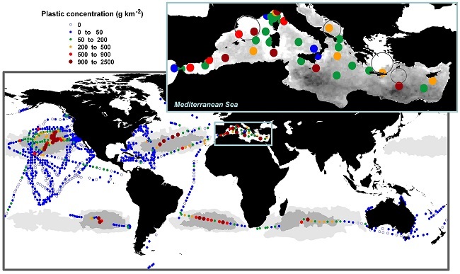
In the global map, dark and light grey areas represent inner and outer accumulation zones, respectively, modelled for the five subtropical gyres; white oceanic areas represent non-accumulation zones. Image: Cozar et al
Not quite mission impossible
“This might sound like mission impossible, but there are reasons to believe it might be indeed doable, at least for certain concentrations,” he said.
“We’re not talking about actually spotting floating litter items but instead to identify a distinct spectral signature of plastic picked up from orbit, in the same way that processing software can today pick out concentrations of phytoplankton, suspended sediments and water-borne pollution.”
Key to the detection is the fact that plastic has specific infrared fingerprints, which are used by the recycling industry to sort the items.
This allows for satellite images from missions such the Sentinel-3 ocean-colour tracker to be checked against aerial coverage, and they can work with ground surveys where drifting plastic is collected from the sea to be assessed in a close-up.
“We hope to get an idea of what kind of concentration of marine litter is viewable from the top of the atmosphere using current technology, or if we’d have to operate from the middle of the atmosphere using aircraft or drones,” Corradi explained. “Or would we have to improve the technology?”
The ultimate goal is to create an accurate global map of litter concentrations, but the technology needs to be perfected first. For now, the findings have been documented in a research paper.