Image: © mrallen/Stock.adobe.com
A Trinity and NUIG research project is combining historical maps of peatlands with modern geospatial datasets, which could help in mitigating the climate crisis.

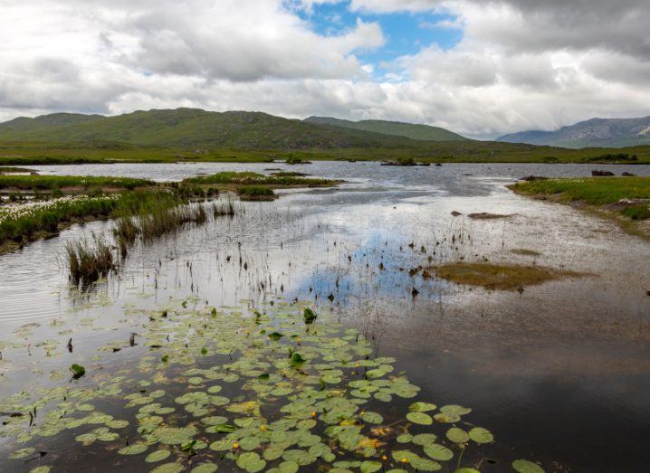
Data plays a critical role in mapping out the environment around us, which can give researchers a better understanding of how to sustainably manage those environments. One initiative that seeks to do that is the RePeat project at Trinity College Dublin in collaboration with NUI Galway.
Using a combination of historical maps from the Bog Commission and modern geospatial datasets, the RePeat project will create an updated derived Irish peat map and combine it with a change detection study.
This aims to improve the estimates of greenhouse gas stocks and help to manage peatlands more sustainably by identifying areas that may be suitable for rewetting and reducing CO2 emissions.
Dr Louis Gilet is a postdoctoral researcher on the RePeat project. With a background in physical and environmental geography, he told SiliconRepublic.com that producing knowledge that helps societies to address ecological and environmental challenges is important to him.
‘Peatlands are essential for water regulation and provide valuable habitats for biodiversity’
– DR LOUIS GILET
“The RePeat project, which combines peatlands, land use changes, historical maps, geospatial tools and carbon dynamics, brings together many of my research interests!”
Over the last two decades, a growing number of scientific papers and reports from environmental associations have emphasised the crucial role of peatlands for mitigating the climate crisis. Peatlands contain about 20pc to 25pc of the total soil organic carbon stock, although they occupy only 3pc of the global land surface.
“While healthy water-logged peatlands are a major carbon sink, peatlands that have been drained and converted for peat extraction, forestry or agriculture become significant carbon sources, gradually releasing the million tonnes of carbon they have accumulated over thousands of years,” he said.
“In addition to climate change mitigation, peatlands are essential for water regulation and provide valuable habitats for biodiversity. They also have important cultural, educational and recreational values.”
With ongoing efforts to meet Ireland’s national climate targets, converting drained peatlands back into carbon sinks by rewetting sites is another action that could be taken to reach this goal.
However, Gilet said the quantification of greenhouse gas dynamics from converted peatlands as well as the identification of sites for rewetting is particularly difficult at present, as many are covered or hidden by forests and grasslands.
“The landcover maps and satellite images show what is above the ground surface, which is appropriate for intact peatlands or extracted peatlands which have a distinct spectral signature. But logically, they will not detect as such converted peatlands whose soils are covered by conifers, deciduous trees, pastures, or crops.”
Combining the old with the new
To combat this problem, the RePeat project is taking 200-year-old maps of peatlands and using them to revise the knowledge of peatland extent in Ireland. It is doing so with funding from the Department of Agriculture, Food and the Marine and the Environmental Protection Agency.
“These old maps were produced by the Bog Commissioners and published between 1809 and 1814. The principal investigators on this project, Dr John Connolly of TCD and Dr Terry Morley of NUI Galway, noted in preliminary investigations in 2018 that these old maps were quite accurate. This accuracy forms the basis of the project,” Gilet said.
“These maps were produced between 1809 and 1814 by several teams of surveyors and engineers distributed across Ireland. This mapping project was initiated by the British Government to find new lands for agriculture.”
While the historical maps are believed to be accurate, peatlands in Ireland have undergone extensive land use change since 1809. However, by digitising the maps and integrating the boundaries into a geographic information system (GIS), they can be georectified.
“The georectification process aligns these old maps with modern day coordinate reference systems. The boundary data from these maps will be extracted using various automatic or semi-automatic classification tools, pixel-based or object-based, and relying on machine learning algorithms,” Gilet explained.
“Various workflows are currently being examined to determine which ones produce the best classification results and accuracy measurements. Deep learning models will be tested as well. This will enable a direct comparison of the peatland area from the 1800s with the current extent.”
Gilet added that an integral part of the project is to assess the present-day extent of relatively intact peatlands using the new National Landcover Map from the Environmental Protection Agency and Ordnance Survey Ireland, ESA Sentinel 2 satellite images and possibly VHR satellite or aerial imagery.
“This will facilitate a 200-year change detection study that will aid identification and assessment of the the converted peatland areas, when compared to the Bog Commission boundaries,” Gilet said.
“This analysis will be conducted using the processing and analysis functionalities of cloud-based geospatial platforms such as Google Earth Engine and ESA’s SNAP toolbox.”
Using the knowledge
The data constituting the updated derived Irish peat map, the thematic map of intact and converted peatlands, and the resulting greenhouse gas inventory will all be compiled in a geodatabase.
“We can also imagine that data from further studies could complement this geodatabase: data on drainage conditions and perhaps on the biodiversity or ownership status of the mapped areas,” said Gilet.
“In this way, we aim to build a methodology that can be used to aid identification of the location of the most relevant sites for rewetting projects.”
As well as helping to refine current knowledge of the extent of Irish peatlands and of the land use changes they have undergone over the past 200 years, the RePeat project also offers the rare opportunity to combine high-quality geospatial datasets produced more than two centuries apart and thus conduct a very long-change detection study.
“Enhanced mapping and characterisation of peatlands can greatly assist stakeholders in the sustainable management of these critical and valuable systems for climate change mitigation and multiple contributions to people,” said Gilet.
Updated, 10am, 2 August 2022: A previous version of this article said maps were produced by the Bog Commissioners and published between 1809 and 1914. This was amended to the correct figure of 1814.
10 things you need to know direct to your inbox every weekday. Sign up for the Daily Brief, Silicon Republic’s digest of essential sci-tech news.