
Anyone who has used Google Earth will have been mightily impressed by the browser-based technology that allows you to choose virtually any point on Earth and then zoom into a particular country, city and even street in just a few seconds. The same principle lies behind a new government-to-business (G2B) service from Land Registry — Landdirect.ie — which is due to go live on 28 April.
By visiting Landdirect.ie, professional users such as banks, solicitors, estate agents, local authorities and government departments will be able to pick out virtually any town or village in the land, visualise a particular property-holding online and then click on it to find out who actually owns it. Currently about 85pc of property in the public is registered and this will show up on the system.
The Land Registry views the new service as the final step in a journey that began in 1999, when it became the first government department — Revenue Commissioners included — to offer an e-government service. It did this by making its core registry information system — the Integrated Title Registration Information System (ITRIS) — available over the internet.
The Land Registry holds two basic types of information: textual (documents) and geographical (maps). The ‘register’ itself consists of a folio — a three-part legal document — with a map attached to it. Initially, professional customers were given online access to folios plus an index of them. At first, only Dublin records were available in electronic format, but over the years the Land Registry undertook a series of projects to electronically capture records going all the way back to 1892 — six million pages of records, all indexed by name, made up into 1.8 million folios.
Users already have access to a number of services via Landregistry.ie. They can conduct a search of properties by owner’s name, view folios and order copies of folios. These services have proven enormously popular with users. More than 9,200 subscribers — roughly 85pc of the Land Registry’s traditional professional customer base — are regularly using the service. Overall, more than 4,200 online business transactions per day — that’s well over a million annually — are being conducted through the website.
Although the system is currently not designed for use by the wider public, the Land Registry is looking at ways to eventually enable this.
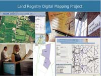
The five-year €25m digital mapping project, which includes a major programme to convert the Registry’s paper-map base of 2.5 million or so land parcels into electronic form over a five-year period, has been a key item on the organisation’s to-do list for a number of years.
The project’s core objective is to improve the service to Land Registry customers by providing a system, known as DMapS, that allows them to search and retrieve mapping information online.
Last July, contracts were signed with two UK-based IT services firms, which are now working with local Irish-based IT firms to implement the project. A contractor called Landmark was tasked with building the system and integrating it with the Land Registry’s existing ITRIS system, while a firm called Laser-Scan won the challenging contract to convert the maps into electronic format. “We had 35,000 large ordnance survey maps with hundreds and sometimes thousands of registrations on each sheet. All that data had to be captured in electronic format,” explains Michael Treacy, corporate services manager at the Land Registry.
The new service is set to further alter the way Land Registry interacts with its clients. Currently, a professional customer wishing to inspect Land Registry maps and locate ownership details from such maps has to visit the Registry offices in person. But once the service goes live just a few weeks from now customers will be able to conduct map searches over the internet and view the results and details from the comfort of their own offices.
Account holders will conduct the searches by selecting the geographical locators which will be visible within their web browsers and the system will then retrieve the folio associated with that locator. These locators will be overlaid on the current Ordnance Survey Ireland (OSi) digital map series and will also be linked to a database of addresses jointly produced by An Post and OSi, known as the GeoDirectory.
But that’s not all. “The Ordnance Survey photo map is another layer behind this,” Treacy explains. “That will be a very valuable additional piece of information that will allow users to put a context on the map they are looking at. If you can turn on a photo map in the background, it gives you a totally different perspective on what you’re looking at.”
The project also covers digitisation of individual land parcels — as opposed to property holdings — in each county. County Westmeath will be the first county to go live, on 28 April, with the remaining 25 counties to be digitised over the next five years.
The Land Registry collects fees of €70m a year for the services it provides, of which roughly €5m comes via Landregistry.ie. Most of the services — be they online or offline — cost only €2.50. Although the fees are modest anyway, Treacy believes the real saving the customer makes is in terms of removing the hassle of visiting the Land Registry offices in person and improving the speed of response. He notes that response times to customer requests have fallen from days to just seconds since it began offering services online.
The development of online services takes a lot of planning and effort but Treacy believes that system is more than paying for itself in terms of improved productivity. “The business case is there. The Land Registry has doubled its output in terms of the number of registrations made every year, with the same number of staff.”
By Brian Skelly


