Image: © master1305/Stock.adobe.com
New resource is revealed for consumers to see how good or bad connectivity is in their neighbourhood.
Telecoms regulator ComReg has made available an outdoor mobile coverage map that allows consumers to check operator coverage and signal levels at locations across Ireland.
The map lets users see what their connectivity is like in terms of 2G, 3G and 4G signal coverage, ranging from very good to good, fair, fringe and, in the worst-case scenario, no coverage.
‘The map will enable users to identify providers that can best meet their individual needs. It will also strengthen the competitive advantage that operators can gain from expanding their coverage’
– JEREMY GODFREY
The map lets users see the level of coverage where they work or live but also make choices between operators based on existing or predicted availability in their area.
The online map allows users to zoom in and out of a particular area or address but also it uses Eircodes and addresses at specific locations down to 10m by 10m.
According to ComReg, the map has been generated by data provided by Eir, Three Ireland and Vodafone, and also includes data for various mobile virtual network operators (MVNOs) such as Tesco Mobile and Virgin Media as well as 48, Lycamobile and Postmobile.
Find out how good coverage is in your area
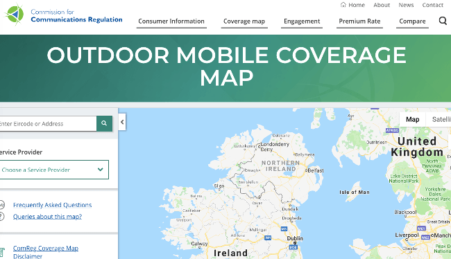
Click to enlarge. Image: ComReg.ie
ComReg said it will update the map on a regular basis to reflect changes in coverage as operators expand their networks. It will also launch a mobile phone app for the coverage map in due course.
“ComReg’s mobile phone coverage map gives users independent and consistent information about the coverage they can expect from different mobile networks at different locations,” said ComReg commissioner Jeremy Godfrey.
“We all have different requirements for coverage, depending on where we live, work, study and spend our leisure time. The map will enable users to identify providers that can best meet their individual needs. It will also strengthen the competitive advantage that operators can gain from expanding their coverage.”
ComReg revealed last December that the demand for data connectivity in Ireland is increasing. It said that the demand for fixed data is growing at 37pc a year while the demand for mobile data is growing at 60pc per annum.
It also revealed that Ireland faces a unique set of challenges in that 76pc of the country is covered by either farmland or forestry; that Ireland’s road density is twice the EU average, with more than 20km for every 1,000 inhabitants; and that there are other hurdles for communication such as long distances from cell sites, environmental barriers such as hills and trees, and a high proportion of one-off housing. Not only that but modern insulation in houses also prevents radio waves from penetrating buildings.
Around 3pc of the population of Ireland lives in 28pc of its geographic area. The urban population accounts for 63pc but is located in just 2pc of the total area of Ireland.
The regulator commissioned three reports to find out how likely it is to achieve at least 30Mbps across the entire country. The reports included: Coverage Obligations and Spectrum Awards from DotEcon, Future Mobile Connectivity in Ireland from Oxera Consulting and Real Wireless, and Meeting Consumers’ Connectivity Needs from Frontier Economics. They are hefty tomes but well worth a read if you are passionate about the subject.
The reports surmise that providing mobile broadband coverage to people by population rather than geographically would be the more financially prudent approach. To reach 95pc of the population would cost €188m, while achieving 99.5pc of the population could cost €511m, according to Frontier Economics. To achieve 99.5pc geographic coverage with data would cost close to €1.9bn.