
Ordnance Survey Ireland (OSI) is making the many datasets from governmental bodies open source using a new geospatial tool called GeoHive.
The decision to launch GeoHive today comes following a report compiled by the OSI entitled: Economic assessment of Ireland’s Geospatial Industry, which looked into the economic value of using geospatial technology and information for the benefit of a country’s citizens.
According to its findings, geospatial information can generate annual savings of €82m in the public sector, time savings with an economic value of €279m, and competition benefits of €104m.
In total, 70 datasets are available for the public to use across 10 base-maps of data collected on Ireland’s nature and environment, as well as its population and economy.
Different factors, including analysis of an area’s soil, could be layered on top of transport services, which can both be made as transparent as the user wishes to focus on one dataset over another.
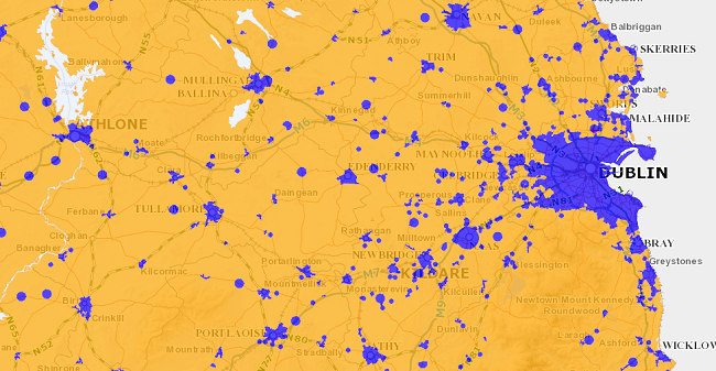
The Government’s high-speed broadband map for 2016. Image via GeoHive
Giving one example, the OSI’s chief executive Colin Bray said: “One of the stories we tell with GeoHive – called ‘buying a property in Ireland’ – gathers together data from many different sources to enable people to view that information in a single site to assist with the evaluation of one location to another. The information presented includes property prices, transport, education and planning.”
The GeoHive geospatial service has been made available across Android and iOS, as well as being accessible on desktop computers.
Speaking at its launch today (3 November), Minister for Communications, Energy and Natural Resources, Alex White TD, said: “GeoHive is going to help us modernise public service delivery by providing a free and accessible portal where it’s easy to find, share and use the State’s location data.
“With data on education, population, travel times, commuting patterns and the labour force in specific towns and cities, it will also provide businesses with information that will help them make investment decisions.”
Ordnance survey map image via Shutterstock


